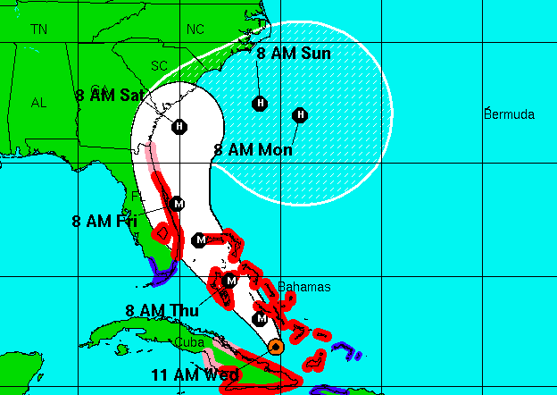
The forecast from the National Hurricane Center on Hurricane Matthew, Sept. 5, 2016. (Credit: NHC)
The latest forecast from the National Hurricane Center shows Hurricane Matthew’s track is significantly changed from just a day ago, when it was predicted to brush the New Jersey coast. But the National Weather Service said its uncertainty was “high” and its forecast confidence was “low.”
The latest forecast track, released at 11 a.m. Wednesday, shows the storm riding the coast from Florida to South Carolina, then moving eastward into the Atlantic Ocean and making a southeasterly turn. While the forecast is subject to change, the new prediction shows that the storm will not be affecting New Jersey in any significant way by Monday.
The storm will briefly make landfall in Florida near Fort Pierce and Port St. Lucie before making the northeast – and then southeast – turn. After that period of time, the forecast is still up in the air.
|
|
And monitor the forecast. Yes, the #Matthew forecast has changed for the better in our region. But, I doubt that forecast is done changing.
— Gary Szatkowski (@GarySzatkowski) October 5, 2016
“Theoretically, if the storm does do a large loop, the East Coast could theoretically have to contend with it again,” said Dan Skeldon, meteorologist for The Press of Atlantic City, in a social media post. “But let’s see if it even loops first.”
New Jersey residents were still cautioned that the storm could kick up heavy surf – making swimming or boating in the ocean dangerous.


Police, Fire & Courts
Brick Physician and Family Killed in Upstate N.Y. Plane Crash


Police, Fire & Courts
Brick Physician and Family Killed in Upstate N.Y. Plane Crash


Police, Fire & Courts
Brick Father and Son Arrested for Drug, Weapons Offenses


